Myanmar
Depending on the Geographical diversity Myanmar possesses variety of tourist sites. In the north east Myanmar has a common border with China, in the east with Laos, in the east and northeast with Thailand, in the northwest with India and in the southwest with Bangladesh, resulting in many overland border entry points. On the other hand different ethnic minorities can be seen at different border regions and giving great opportunity for tourists to explore the culture tradition of colorful ethnic groups during their visit. From the border entry points, High Mountains National Parks, Wild Life Sanctuaries and preserved forests areas, tourist can enjoy hiking, trekking, bird watching, insects and plant collection.
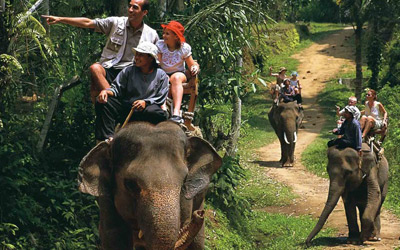
Myanmar is also famous for timber production. One may experience, elephants at work by staying overnight at the elephant camps. After that you can take a route to the central plains of Myanmar to get the feel of tropical environment while exploring the Culture and Architecture of Ancient Cities dated 5th to 18th centuries. Since the entire south eastern part of Myanmar coastline touched the Indian Ocean in Mergui archipelago, Myanmar offers pristine Beaches with more than 1,000 islands where water games and sports can be enjoyed safely.
Ethnic Group in Myanmar
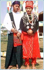
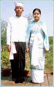
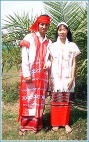
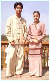
Myanmar is a union of 135 national races with their own culture, languages and dialects. The major races are Bamar, Chin, Kachin, Shan, Kayah, Kayin, Mon and Rakhine The population of Myanmar is over 51 million with Bamar, the majority race making up about 70%. Republic of Union of Myanmar has seven states and seven divisions. The seven divisions are made up of:-Shan, Kachin, Karen, Rakhine, Mon, Kayar and Chin. The rest of the states are Bamar. All the ethnic groups and Bamar people can be found in all states and divisions.
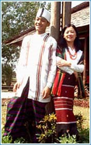
Kachin
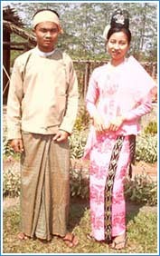
Kayah
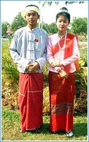
Kayin
Chin
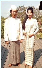
Burma
Mon
Rakhine
Shan
Climate
Myanmar possesses tropical dry and wet monsoon climate. From mid May to late October are the rainy months. There is no rain from November to mid May. Generally Myanmar undergoes an annual three seasons cycle; Summer, Rainy and Winter.
Summer is from March to June and Rainy Season is from Mid-May to end of October. Winter is from November to February.
Due to the topography Myanmar has different terrain with different temperature and rainfall. In Winter temperature is pleasant throughout the country. In the highlands at night temperature can drop to near freezing point.
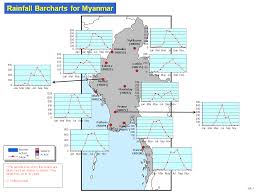
Rainfall also vary region wise. In July it rains only 95 mm at Bagan and Mandalay while 550 mm in Yangon. You may visit Myanmar anytime as you can choose the site which has good climate at that time.
– Monthly Temperature Record in ‘C –
| S.N | States and Divisions | Jan | Feb | Mar | Apr | May | Jun | Jul | Aug | Sep | Oct | Nov | Dec |
| 1. | Kachin State | 17.7 | 19.7 | 23.1 | 26.3 | 27.8 | 27.8 | 27.7 | 28.1 | 27.5 | 25.9 | 21.9 | 18.5 |
| 2. | Kayah State | 17.4 | 19.6 | 23.6 | 26.2 | 26.1 | 24.9 | 24.1 | 4.0 | 24.3 | 23.3 | 21.1 | 17.8 |
| 3. | Kayin State | 25.5 | 27.0 | 29.5 | 31.2 | 29.5 | 27.0 | 26.5 | 26.4 | 27.6 | 28.8 | 28.0 | 25.9 |
| 4. | Chin State | 10.3 | 12.2 | 15.7 | 17.4 | 19.2 | 19.4 | 19.5 | 19.2 | 19.0 | 17.5 | 14.5 | 9.9 |
| 5. | Sagaing Division | 20.7 | 23.3 | 27.6 | 30.8 | 32.0 | 30.7 | 30.4 | 29.9 | 29.0 | 27.7 | 25.2 | 20.9 |
| 6. | Tanintharyi Division | 26.8 | 27.3 | 28.6 | 29.2 | 28.1 | 26.9 | 26.3 | 26.2 | 26.4 | 27.0 | 27.1 | 26.1 |
| 7. | Bago Division | 23.6 | 25.1 | 29.4 | 30.1 | 29.3 | 26.7 | 27.0 | 26.3 | 27.0 | 27.5 | 26.4 | 23.7 |
| 8. | Magway Division | 20.9 | 23.4 | 27.7 | 30.8 | 30.9 | 28.5 | 27.8 | 27.5 | 27.8 | 27.4 | 24.4 | 21.2 |
| 9. | Mandalay Division | 21.8 | 24.5 | 28.4 | 31.6 | 31.6 | 30.6 | 30.7 | 29.9 | 29.6 | 28.5 | 25.5 | 21.8 |
| 10. | Mon State | 25.4 | 25.5 | 28.8 | 30.3 | 28.6 | 26.6 | 26.2 | 26.2 | 27.0 | 28.0 | 27.2 | 25.3 |
| 11. | Rakhine State | 21.0 | 22.7 | 25.8 | 28.6 | 29.0 | 26.9 | 26.5 | 26.6 | 27.3 | 28.0 | 26.5 | 22.8 |
| 12. | Yangon Division | 24.9 | 26.5 | 29.0 | 30.5 | 29.4 | 27.4 | 26.9 | 26.6 | 27.1 | 27.6 | 27.0 | 25.0 |
| 13. | Shan State | 15.3 | 17.0 | 20.5 | 22.4 | 22.2 | 21.3 | 20.9 | 20.6 | 20.8 | 20.0 | 17.9 | 15.4 |
| 14. | Ayeyarwady Division | 24.1 | 25.2 | 28.3 | 30.4 | 30.0 | 27.9 | 27.1 | 27.1 | 27.4 | 28.0 | 26.9 | 24.6 |
– Monthly Rainfall Record in inches –
| S.N | States and Divisions | Jan | Feb | Mar | Apr | May | Jun | Jul | Aug | Sep | Oct | Nov | Dec |
| 1. | Kachin State | 12 | 25 | 32 | 28 | 218 | 381 | 454 | 320 | 345 | 189 | 47 | 12 |
| 2. | Kayah State | 0 | 5 | 12 | 33 | 125 | 128 | 145 | 232 | 177 | 88 | 48 | 5 |
| 3. | Kayin State | 1 | 9 | 13 | 35 | 314 | 850 | 1077 | 1063 | 536 | 200 | 30 | 12 |
| 4. | Chin State | 5 | 23 | 51 | 82 | 171 | 266 | 285 | 305 | 251 | 154 | 80 | 6 |
| 5. | Sagaing Division | 3 | 13 | 105 | 31 | 145 | 311 | 426 | 315 | 315 | 177 | 38 | 4 |
| 6. | Tanintharyi Division | 13 | 31 | 38 | 77 | 417 | 874 | 1055 | 1204 | 643 | 303 | 27 | 10 |
| 7. | Bago Division | 0 | 4 | 16 | 26 | 186 | 450 | 495 | 521 | 352 | 148 | 57 | 2 |
| 8. | Magway Division | 0 | 6 | 15 | 21 | 103 | 132 | 133 | 202 | 183 | 172 | 66 | 8 |
| 9. | Mandalay Division | 0 | 5 | 8 | 29 | 106 | 145 | 136 | 168 | 156 | 112 | 45 | 4 |
| 10. | Mon State | 2 | 9 | 16 | 54 | 463 | 1115 | 1247 | 1265 | 653 | 261 | 36 | 10 |
| 11. | Rakhine State | 5 | 19 | 13 | 29 | 324 | 1355 | 1415 | 1126 | 615 | 253 | 161 | 9 |
| 12. | Yangon Division | 0 | 10 | 14 | 17 | 234 | 583 | 611 | 609 | 361 | 179 | 48 | 2 |
| 13. | Shan State | 3 | 10 | 17 | 54 | 136 | 187 | 227 | 258 | 216 | 160 | 85 | 12 |
| 14. | Ayeyarwady Division | 0 | 1 | 3 | 20 | 223 | 610 | 633 | 703 | 376 | 181 | 77 | 9 |
History
With reference to the Archaeological evidence the land that was to become Myanmar has been inhibited since at least 2500 BC. In general Tibeto-Burman migrated from Northwest and Mon-Khmar as well from Southeast. Tibeto-Burman were known as the Pyu race which is the earliest civilization and founded three kingdoms, Beikthano, Hanlin and Thayekhittaya. These Kingdoms flourished since the 3rd century until 9th century BCE before vanquished Nan Chao forces of China’s Yunan Province at present. However, they left a wealth of gold artifacts, which had proven their prosperity and the richness of culture.
Along the Western coast, Rakhine had established small kingdoms, Dhanyawaddy (4th to 6th century), Wethali (4th to 9th century) and Mrauk U (13th to 18th century). According to Myanmar Official history, the Mon capital occupied areas around Thaton in present day. Inscriptions left behind by the civilization they developed referred to this area as Suvannabhumi.
Around 8th or 9th century Bamar came into South of Myanmar from eastern Himalayas. Once the Pyu were vanquished the Bamar supplanted the Pyu in central Myanmar, a region that has since been the true cultural heartland of Myanmar. After Bamar came into conflict with Mon in a long and complicated struggle in the 11th century the great King Anawahta ascended to throne and consolidates the First Myanmar Empire in the central plains. It was due to his efforts that Theravada Buddhism flourishes in the country today and the temple studded plain at Bagan is his legacy. After King Anawrahta passed away in 1077, Kyansittha (1084-1113) attempted to unify Myanmar’s disparate people and later Kings like Alaungsithu and Htilominlo built beautiful shrines, but essentially Bagan reached its peak with Anawrahta.
Bagan’s decline coincided with the rise of Kublai Khan and his Tartars in the north. They invaded Bagan in 1287 then Bagan Kingdom fell to ruins. Since then Myanmar remained in chaos, several smaller Kingdoms were founded by descendents of the Bagan Kings. One of that small kingdom came to power in the 16th century was the Kingdom in Taungoo. In 1531, the fourteen year old Crown Prince Tabin Shwe Hti ascended the throne on his father’s death. Then King Tabin Shwe Hti founded the Second Myanmar Empire. In 16th century a series of Taungoo Kings extended their power to the north, nearly to Inwa, then south, taking the Mon Kingdom and shifting their own capital to Bago, named Hanthawaddy.
In 1550, King Bayint Naung came to the throne, reunified all Myanmar and brought the empire to even higher greatness. With Bayint Naung’s death in 1581, his successors did not have his vision or strength and the Kingdom of Hanthawaddy went into decline. And in 1636, the capital was shifted north from Bago to Inwa. In the 18th century the decline became again as hill tribes started to raid central Myanmar and the Mon again broke away and established their own Kingdom in Bago.
In 1752 the Mon took Inwa, but in the same year Alaungpaya came to power. He founded the Third Myanmar Empire and the Konbaung Dynasty of monarchs, who were to be the last kings in Myanmar. Alaungpaya rushing back and forth across Myanmar, conquering, defeating and destroying all who opposed him. His conquest of Lower Myanmar was marked by his renaming of Dagon, a small town where the great Shwedagon Pagoda is situated, to Yangon meaning “End of Strife”.
Since his reign and increasingly throughout the rule of his descendents, European were regular visitors to the country and court. It was a time of French, Dutch and British imperialism and few Asian countries were safe from their clutches. Myanmar fell completely into British hands in 1885 and the last Monarch, King Thibaw and his family, were exiled to India. British ruled the country until Myanmar finally won Independence on 4th January, 1948.
Geography
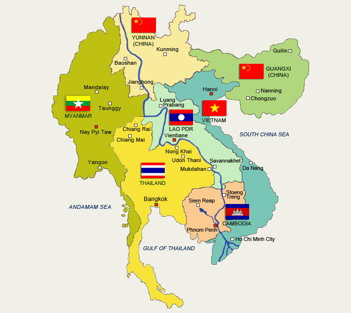
Myanmar covers an area of 676,577 sq km, bordering with Thailand and Laos at the East and Bangladesh to the West. The entire Northwestern side is touched with India while Northeastern border is sharing with China and Southeastern part also bordering with Thailand. Oppose to that Southeastern part is the 2051 km long coastline touching with Indian Ocean.
Then Myanmar’s Northern tip sits on the Himalaya mountain ranges and there were snowy peaks. In Kachin state, Southeast Asia’s highest mountain “Mount Kahkaborazi”, 5881 km high Snowy Mountain is the tour highlight. Also “Mount Victoria”, 3053 km is in Chin State bordering India. Shan State is in the East bordering with Laos and Thailand, that form “Golden Triangle”.
Surprisingly the landscape is totally different in Central of Myanmar. Central Myanmar is the plain dry zone with tropical climate where great Archaeological zone Bagan and Mandalay the last capital of Myanmar dynasty is located.
The mighty river Ayeyarwaddy (2000 km) flows from hilly region of the North across the central Myanmar and empty out to the sea in the South. River Ayeyarwaddy is navigable year round for 1500 km and has played a major role in domestic transport and communications for centuries. Other major rives are the Chindwin (navigable for 792 km), which joins the Ayeyarwaddy between Mandalay and Bagan; the Kaladon (navigable for 177 km); the Sittoung (non-navigable due to strong currents); and the Thanlwin river (navigable for just 89 km) which has its head waters in China then forms the border between Myanmar and Thailand. The Mekong River forms the border between Myanmar and Laos.

There are three mountain ranges laying from south to north, one in the east, one in the middle and one in the west that protect the storm as natural barriers. Very deep forests thrive on that mountain ranges. Myanmar is fortunate in possessing huge stands of teak and other hardwood. Off Myanmar’s southwestern coastline is the Mergui Archipelago of 800 islands with beautifully preserved coral reefs.
Myanmar has vast and fertile delta region form from the tributaries of Ayeyarwaddy River near the sea at south where different species of mangrove thrive in Ayeyarwaddy Division.
Mode of Entry | By Air Route
International Air Link To Myanmar
| No | Air Line | Route | Day Service |
| 1 | Thai Airways | RGN BKK | Daily |
| 2 | Bangkok Airways | RGN BKK | Daily |
| NYT BKK | MON,TUE,WED,THU and FRI | ||
|
3
|
Air Asia | RGN DMK | Daily |
| MDL DMK | Daily | ||
| RGN KUL | Daily | ||
| 4 | Nok Air | RGN DMK | Daily |
| 5 | Myanmar Airway International | RGN BKK | Daily |
| RGN SIN | Daily | ||
| RGN CAN | TUE,THU,FRI,SAT and SUN | ||
| RGN KUL | TUE and THU | ||
| 6 | Singapore Airlines Silk Air |
RGN SIN | Daily |
| MDL SIN | TUE,THU and SAT | ||
| SIN MDL | TUE | ||
| 7 | JET Star | RGN SIN | Daily |
| 8 | Tiger Air | RGN SIN | Daily |
| 9 | Myanmar National Airline (UB) | RGN SIN | Daily |
| RGN HKG | MON,WED,FRI and SUN | ||
| 10 | Malaysia Air | RGN KUL | Daily |
| 11 | China Air | RGN TPE | MON,WED,THU,FRI,SAT and SUN |
| 12 | Air China | RGN KMG | Daily |
| RGN PEK | MON,WED,FRI and SUN | ||
| 13 | China Southern | RGN CAN | MON,WED,FRI and SAT |
| China Eastern | RGN KMG | Daily | |
| 14 | Vietnam Airline(VN) | RGN HAN | Daily |
| RGN SGN | TUE,WED,THU,FRI and SUN | ||
| 15 | Dragon Air | RGN HKG | Daily |
| 16 | Korea Air | RGN ICN | Daily |
| 17 | Air Nippon | RGN NRT | Daily |
By Land Route
Overland entry is permitted to Thai, Chinese and Indian tourists with border passes and to third party tourists with visa at designated checkpoints along Myanmar’s borders with Thailand, China and India. Prior permission is required for tourists entering the country through border checkpoints.Border check points are Muse, Nam – Khan, Kyu – gok, Lwe – je and Kun – lone from Yunan province of China and Tachileik, Myawaddy, Three Pagoda Pass and Kawthaung from Thailand.Bravo Travels & Tours has special arrangement for land route entry.
By Sea
Myanmar has river port which ocean going vessels can berth year round. Then huge passenger cruise ships usually come by their own arrangement. We have pleasure to assist for the land operations with very reasonable price. Please do not hesitate to
contact us when your cruises visit Myanmar.